Both Wrecks A4 and B4 are standard canal boats located near Larrabees Point in the Vermont waters of Lake Champlain. They were discovered in 1984 by the Champlain Maritime Society and relocated during the 1992 Mount Independence-Fort Ticonderoga Underwater Survey by the LCMM. These sites were again relocated during the 2003 Lake Survey, and dive verified in July 2005.
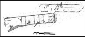
Preliminary archaeological drawings of Wrecks A4 and B4.
Drawn by Adam Kane, Krissy Kenny, Joanne DellaSalla and Chris Sabick.
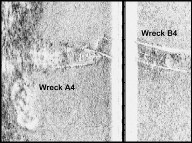
Sonar image of Wrecks A4 and B4 documented during the 2003 Lake Survey.
Wreck A4 is a standard canal boat whose remains consist of the sides, a longitudinal bulkhead, the rudder, sternpost, a windlass and the stem. Although the bottom of the vessel is buried, most of the structure is exposed above the sediments. The vessel is 84ft (25.6m) long indicating it was built for the first expansion of the Champlain Canal locks between 1858 and 1873. The hull is constructed plank-on-frame with a portion of the starboard side of the hull preserved up to the gunwale. Most of the sides, however, are significantly deteriorated.
The interior of the vessel has a solid timber bulkhead composed of vertical stanchions and horizontal planks running along much of its length. The sternpost and rudderpost are both still preserved up to their original height. The rudder is a barn door type rudder with the tailboard still present. The bow contains the remains of an iron windlass which has fallen into the bottom of the hull. The stem is standing its full original height. During the 2005 inspection a number of bricks were noted inside the hull especially toward the bow. These may represent the remains of the boat’s cargo.
Wreck B4 is an unrigged canal boat lying directly adjacent to Wreck A4. Examination of this site proved difficult due to extremely limited visibility and accumulated driftwood in the hull remains. The wreck is in shallow water (10-12ft [3-3.7m]) and is badly broken up, probably due to the action of winter ice. Portions of the bow, sides, and stern are present on the site, which measures 94ft 8in (28.8m) in length and between 15ft 6in (4.7m) and 18ft (5.5m) in width. The vessel’s dimensions indicated that it was built after 1873.
The bow appears to have been scow shaped and was supported by at least eight rake timbers. These timbers have all pulled loose from their original locations, making the shape of the bow difficult to decipher. The sides of the wreck consist of edge-fastened planking with a maximum of 2ft (.6m) of planking exposed above the mud line. Only a small portion of each side is still oriented vertically, the remainder has splayed out to either side. It is for this reason that there are a range of beam measurements. The sides were supported by deck beams of which five are still present on the wreck. Three of these have pulled loose from their original positions and now rest in the silt inside the hull remains while two remain attached at both sides. It is from these locations that the beam measurement of 15ft 6in (4.7m) is derived. Only a single element of the stern structure remains on the site. It appears to have been one of the horizontally oriented timbers that is often used to top stern construction in canal boats, referred to as a transom log.
Information Source:
Adam I. Kane, A. Peter Barranco, Joanne M. DellaSalla, Sarah E. Lyman and Christopher R. Sabick, Lake Champlain Underwater Cultural Resources Survey, Volume VIII: 2003 Results and Volume IX: 2004 Results. Lake Champlain Maritime Museum, 2007.
A. Peter Barranco, Jr. Ticonderoga’s Floating Drawbridge, 1871-1920, Demonstration Report. Grand Isle, Vermont: Lake Champlain Basin Program, 1995.
Scott A. McLaughlin, History Told from the Depths of Lake Champlain: 1992-1993 Fort Ticonderoga-Mount Independence Submerged Cultural Resource Survey. Ferrisburgh, Vermont: Lake Champlain Maritime Museum, 2000.